Severe storms to pose risk to lives and property through Memorial Day
Disruptive and dangerous thunderstorms will erupt and advance from the central United States to the East Coast during the Memorial Day weekend, AccuWeather meteorologists warn.
"We have entered a new very stormy period that coincides with the first unofficial holiday weekend of the summer," AccuWeather Chief On-Air Meteorologist Bernie Rayno said, "Each day [and night] through Monday will bring its share of dangerous storms."
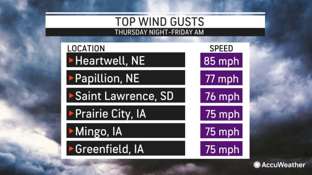
Thunderstorms that erupted Thursday afternoon over the central Plains organized into a solid line of quick-moving severe weather. The advancing, bowing line of storms located over Iowa at the start of the day Friday has met the criteria of a derecho defined by the National Weather Service. The line has produced wind gusts of 58 mph or greater along a path at least 400 miles long. Nationally, there were nearly 300 severe weather incidents Thursday, including nearly two dozen filtered tornado reports. Most severe weather was over the Great Plains, with some scattered reports east of the Mississippi River.
 |
The derecho was weakened as it pushed across southern Wisconsin and northern Illinois but continued to produce locally damaging wind gusts, an occasional tornado, and torrential downpours as it approached the shores of Lake Michigan, and home to Chicago and Milwaukee at midday on Friday. More storms erupted from the western Great Lakes region to Texas into Friday night, and numerous reports of damaging wind gusts and hail occurred across this region.
In some of the more powerful instances, wind gusts will reach or exceed Category 1 hurricane force, which is 74 mph, in some of the storms through Monday. However, in the most extreme cases during the weekend, the AccuWeather Local StormMax? winds will be considerably higher.
Many areas in the Central and Eastern states will be hit by one or more rounds of thunderstorms this weekend. When accompanied by downpours and gusty winds, these can ruin outdoor gatherings, such as weddings, memorial parades or family cookouts.
Strong wind gusts can hit some areas, knocking over trees, cutting power or damaging homes and businesses. In other cases, large hail can break windows, damage crops and dent vehicles. Torrential downpours associated with many storms can briefly flood streets, secondary rural and suburban roads and even major highways.
In a few extreme cases, inches of rain may pour down in an hour, leading to life-threatening flash flooding, especially in the Ozark Mountains and the southern Appalachians, which are popular locations for holiday camping trips.
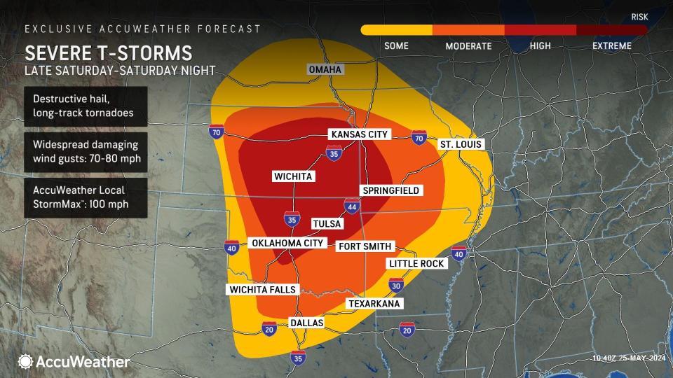
AccuWeather meteorologists are closely monitoring the situation from Saturday to Sunday, as a large complex of severe thunderstorms may roll for hundreds of miles and could lead to dozens of damaging wind and flash flood incidents from central Oklahoma and Kansas to southern and central Missouri and northern Arkansas and perhaps to portions of Illinois, Indiana, Kentucky and Tennessee.
 |
The StormMax? wind gust for Saturday is rated at 100 mph for portions of the central and southern Plains to the mid-Mississippi Valley. That intensity is as strong as a Category 2 hurricane.
Even if a large complex of severe thunderstorms fails to form, multiple powerful thunderstorms will take over.
The latest indications are that many of the storms over the Great Plains states may wait until the end of the day so that most of the daylight hours are fine for outdoor plans. However, thunderstorms may erupt very quickly, like a lid coming off a jar of hornets. While there may be a greater concentration of severe weather over Kansas and Missouri, the storms that erupt from Oklahoma and Arkansas to Texas may be the most intense but sporadic.
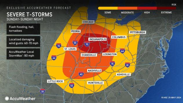
Tornadoes are likely to occur in the most violent storms during the extended holiday weekend. The risk of tornadoes may be greatest over parts of the central and southern Plains Saturday, the mid-Mississippi, Ohio and Tennessee valleys Sunday, and then parts of the mid-Atlantic region on Memorial Day. In portions of the Central states, the risk of tornadoes may continue after dark Saturday and Sunday.
 |
Wichita, Kansas and Tulsa, Oklahoma, will be at a high risk for violent storms, including long-track tornadoes, Saturday. St. Louis and Louisville, Kentucky, will be at a moderate risk of severe weather, including tornadoes, Sunday.
Severe thunderstorms are likely to threaten Sunday's Indianapolis 500, which is scheduled for early in the afternoon. Last year, over 300,000 people attended the world-famous race. With dangerous thunderstorms in the forecast, attendees should prepare for weather-related delays or postponements.
A few hours later, another big auto race will occur at Charlotte Motor Speedway, North Carolina. NASCAR's grueling 600-mile stock car event runs well into the night. At this time, it appears that pop-up thunderstorms will be nearby and could trigger rain and lightning delays. Severe weather may hold up to the west over the North Carolina mountains.
 |
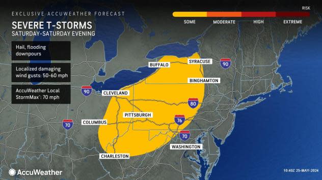
A separate zone of heavy to locally severe thunderstorms may evolve from the central Appalachians to the eastern Great Lakes Saturday, where the primary threats will be from strong wind gusts and hail.
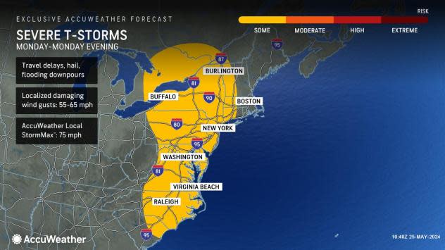
While the extent of severe thunderstorms in the East on Memorial Day may be limited to parts of the region, the strongest storms still carry some risk of tornadoes.
 |
Cities at risk of severe weather Monday include Washington, D.C., and Philadelphia. A cool breeze from the Atlantic may limit severe weather in New York City and Boston to perhaps later in the day or at night. Severe storms are forecast to erupt as far north as Canada's St. Lawrence and Ottawa River valleys.
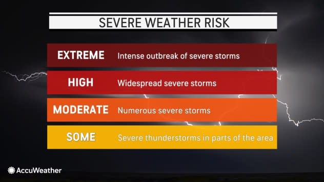
AccuWeather utilizes severe weather areas to alert the general public. The most common range from some (yellow) risk, where potentially damaging storms will affect part of the area, to moderate (orange), where numerous severe thunderstorms are anticipated. A high (red) risk zone is uncommon and denotes widespread severe thunderstorms. An extreme (burgundy) risk zone is rare but signifies the likelihood of an intense outbreak of severe weather.
 |
Any severe thunderstorm is capable of producing a brief tornado.
Motorists and those outdoors are strongly encouraged to watch for rapidly changing weather conditions.
As a general rule, if thunder can be heard, there is a risk of being struck by lightning, even in the absence of severe weather advisories. Avoid being caught in a multiple-vehicle accident by slowing down before torrential downpours arrive or exit the highway until the storm passes.
Want next-level safety, ad-free? Unlock advanced, hyperlocal severe weather alerts when you subscribe to Premium+ on the AccuWeather app. AccuWeather Alerts? are prompted by our expert meteorologists who monitor and analyze dangerous weather risks 24/7 to keep you and your family safer.

