2024 hurricane season breaks an unusual record, thanks to hot water
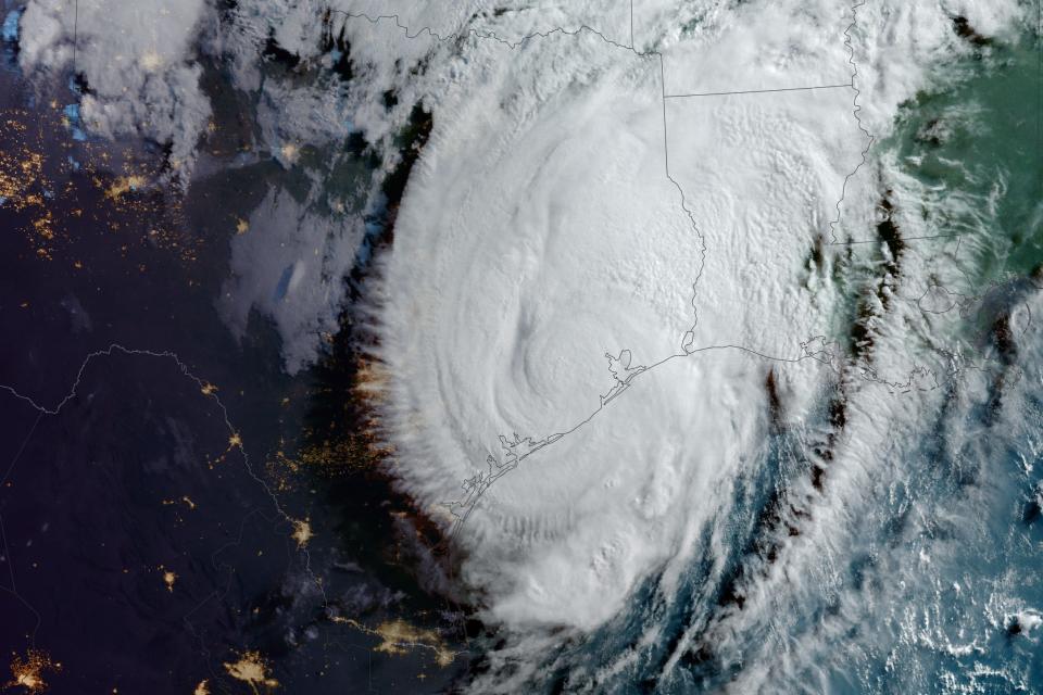
The record-breaking Hurricane Beryl in early July overshadowed the opposite conditions in the Pacific Ocean, where island residents have seen lower tropical cyclone activity than normal.
Seasonal hurricane outlooks had forecast busier-than-normal activity in the Atlantic Ocean and a quieter season in the hurricane-prone regions of the Pacific — and so far that is holding true. On July 3, for the first time since the satellite era began in 1966, the entire North Pacific saw no named storm activity between June 1 and July 3, said Phil Klotzbach, a senior research scientist at Colorado State University.
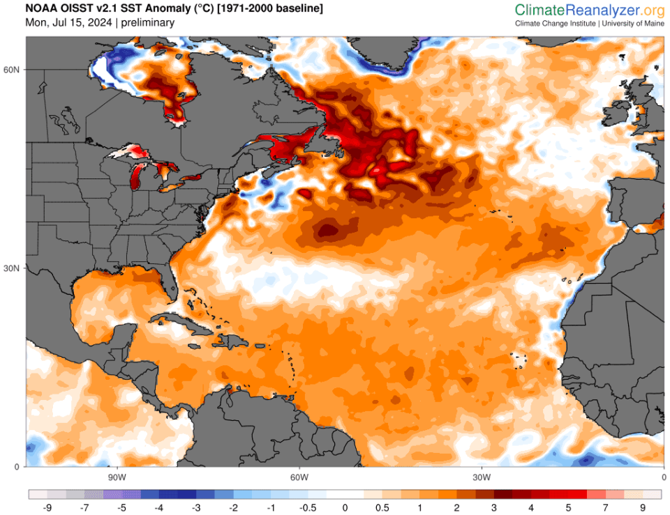
In what might seem like a surprising twist, the same phenomenon – crazy warm water temperatures across much of the North Atlantic – is influencing storm activity in both oceans, Klotzbach said.
Scientists compare hurricane season activity through an index known as Accumulated Cyclone Energy. It calculates the total energy of a hurricane season by the frequency of storms and maximum wind speeds of each hurricane over its lifespan. This year, for the first time in recorded history, the Atlantic had generated more accumulated cyclone energy through July 9 than the entire Pacific, Klotzbach said.

What’s happening with hurricane seasons in the Pacific?
In the far western Pacific, it was "one of the slowest starts to tropical cyclone season," said Landon Aydlett, warning coordination meteorologist for the National Weather Service field office in Guam.
The western North Pacific had only one typhoon in May, and "it's only the second time on record (since 1950) that the western North Pacific has gone without a named storm from June 1 - July 15," Klotzbach said. "The other year was 1975."
The Northern Hemisphere has only produced 6 named storms (>=39 mph tropical cyclones) so far this year. That's the fewest Northern Hemisphere named storms through July 18th since 1969. While #Hurricane #Beryl was a long-lived powerful storm, the North Pacific has been very quiet. pic.twitter.com/8QOMUk4Op8
— Philip Klotzbach (@philklotzbach) July 18, 2024
In the eastern North Pacific, the birth of Tropical Storm Aletta on July 4, nearly 200 miles west of Mexico, was the latest start to the season on record in that hurricane region, beating the previous record set in 1969 by a day, Klotzbach said. Aletta's life as a tropical storm was brief, lasting only a day. This is the first time since 1972 that only one named storm has formed in the eastern North Pacific through July 16th.
But activity finally began to pick up over the weekend. Forecasters at the Joint Typhoon Warning Center this week were watching two systems, Typhoon Gaemi, roughly 400 miles from Taipei, Taiwan, and Tropical Storm Prapiroon, about 150 miles east-southeast of Hanoi, Vietnam. The National Hurricane Center was monitoring three potential systems in the Eastern and Central Pacific.
What caused the lack of storm activity in the Pacific?
A variety of things contribute to tropical storm formation and frequency in any given season, including natural climate cycles and multi-decadal patterns.
Several factors are at play in the Pacific this summer, including the lack of a strong monsoon trough in the western North Pacific and too much easterly shear in the eastern North Pacific, Klotzbach said. That's where the warm Atlantic is having an influence.
"Water temperatures in the tropical Atlantic spiked dramatically" from March to June of 2023 and have remained near or at record warm levels since, Klotzbach said. Thanks to global wind patterns, what happens in one location can have a direct effect on what happens in another.
The Atlantic and Pacific are influenced by the three phases of the weather phenomenon known as the El Ni?o-Southern Oscillation. They include El Ni?o, La Ni?a and the neutral phase. El Ni?o typically favors more storm activity in the Pacific and less activity in the Atlantic, although the warm temperatures in the Atlantic last summer gained an upper hand, leading to a busier season than expected.
Hotter temperatures in the Atlantic also favor a sinking motion over the eastern Pacific, in a La Ni?a-like circulation that favors upper-level easterly winds in both oceans, Klotzbach said. In the Atlantic, that pattern reduces westerly wind shear, making conditions friendlier for storm formation. In the eastern North Pacific, those easterly winds increase the wind shear affecting tropical storms, preventing them from stacking the high cloud tops that help storms grow more powerful.

What about longer-term trends seen in the Pacific?
In the western North Pacific, typhoons have seen a 30% decrease in cyclone frequency, based on a linear trend analysis between 1990-2023, Klotzbach said.
Hurricane researchers continue to study the influence of climate change and other factors in tropical cyclones and typhoons.
Some researchers have found that human-caused aerosols and air pollution may influence the decline in Pacific cyclones when comparing 1980-2000 with 2001-2020, said Jeff Masters, a meteorologist and former Hurricane Hunter and author at Yale Climate Connections.
Despite predictions of a more El Ni?o-like climate because of human caused-climate change, the trend toward a more La Ni?a-like climate has led to large-scale cooling over the eastern tropical Pacific over 40 years, Masters and his colleague Bob Henson wrote last year.
Why is the Atlantic so warm?
Scientists attribute the unusually warmer waters in the Atlantic primarily to a weaker-than-normal subtropical high pressure that led to weaker trade winds, Klotzbach said.
Scientists are working to determine what caused that weakness and why it continues to persist. However, Klotzbach said, human-caused global warming also plays some role in the warmer water temperatures.
Climate change is an "actor in the background" that has an influence on just about everything, said Brian McNoldy, a senior research associate at the University of Miami's Rosenstiel school. "I'd be hesitant to blame (or not blame) climate change for any specific events," he said, because natural variability will be superimposed on that trend.
A changing climate
Other recent research indicates tropical activity could continue to decrease across the western Pacific with a warming atmosphere and warming oceans, Aydlett said.
"That's good news for islanders across the region. The bad news is that storms could be more slow-moving and be filled with a lot more moisture," he said. "We are in a changing climate. We have to roll with the punches."
Even though last year was a slow season in that region, they had two big storms. In northern Guam, recovery from one of those cyclones, Mawar, continues more than a year later, Aydlett said.
"Whatever nature throws at us, we always have to be ready and prepared," he said. "It's only a matter of time before the next storm threatens."
Dinah Voyles Pulver covers climate change and the environment for USA TODAY. She's been writing about hurricanes and extreme weather for more than 30 years. Reach her at [email protected] or @dinahvp.
This article originally appeared on USA TODAY: 2024 hurricane season breaks an unusual record, thanks to hot water
