Where will Buncombe County focus conservation efforts? New maps, tool shed light

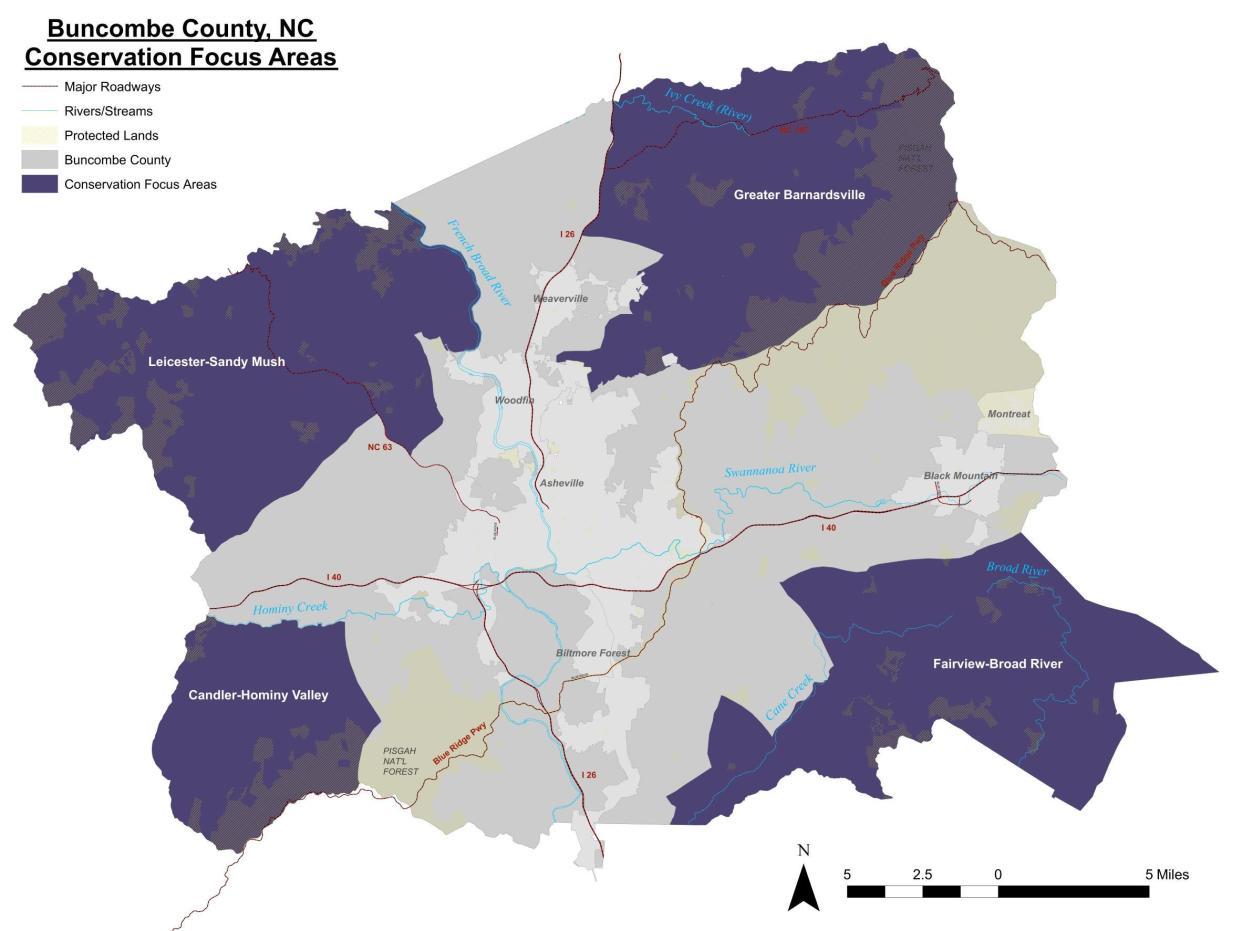
A new online tool from Buncombe County paints a picture of the 18% of land currently conserved in the county and the areas where the county's two conservation-focused boards will focus efforts for the future.
Buncombe County commissioners declared in 2022 that by the end of 2030, the county will have helped conserve at least 20% of the county's total acres. The groups tasked with the initiative are the Agricultural Advisory Board and the Land Conservation Advisory Board, which both have slightly different objectives but that share the same goal ― to conserve county land for future generations.
“I hope this tool helps people understand that there is a conscious, research-based approach to the County’s conservation easement process and our conservation focus areas,” Farmland Preservation Program Manager Ariel Zijp said in a county news release.
Conservation:Pisgah, Nantahala plan done: Forest service still seeking feedback, logging fears remain
Land conservation is important, according to the online tool, because it provides both environmental and public health benefits like higher air and water quality, food security, climate resiliency, recreation and education opportunities and the protection of wildlife habitats.
The maps show that, right now, conservation primarily exists around the northeast and southwest corners of the county, as the Pisgah National Forest makes up a considerable chunk of the currently conserved land. Asheville sits roughly in the middle of Buncombe County.
Privately conserved land through the county's partners dot the landscape but are concentrated primarily in the northwest and southeast parts of the county, plus around the Pisgah National Forest. The county partners with the Southern Appalachian Highlands Conservancy, Conserving Carolina and Riverlink, which are all nonprofit land trusts.
Maps also show regions in which the county hopes to continue to encourage conservation, which are the four corners of the county: Greater Barnardsville in the northeast, Fairview-Broad River in the southeast, Leicester-Sandy Much in the northwest and Chandler-Hominy Valley in the southwest.

More:Land conservation win: Grandfather Mountain State Park in WNC grows by 24 acres
Golf Course:What's the latest at Asheville Municipal Golf Course? Tree removal, ongoing litigation
Answer Man: What is status of hazardous CTS Superfund site cleanup in South Asheville?
The maps were created by looking at a number of different factors, the tool says, which are:
Ecology: Protecting and connecting ecologically sensitive areas.
Water Quality: Protecting land from development to reduce pollution and sediment in waterways.
Working Lands and Farmland: Protecting land producing food, fuel and fiber for future generations.
Ridges and Slopes: Protecting steep-slopes from development, protecting soil, water quality and views.
Proximity to Protected Land: Protecting blocks of land together brings together habitats and protects rural communities.
Large Parcels: Protecting large parcels of land makes linking land easier and increases positive impacts of conservation.
Soils: Protecting prime farmland soil can help increase agricultural yields.
More:Woodfin neighbors vs. developer: Appeal process continues for steep-slope development
Search for Lost Man:Search continues for missing Madison man last seen in French Broad River; dog, boat found

The two Boards consider different factors when deciding whether or not to recommend a conservation project to the Buncombe County Board of Commissioners, but the maps made by each Board largely overlap.
To conserve land, the Boards use conservation easements, which is a legal process that landowners can use to sell certain rights of a land, usually the rights to things like dense development, to a government entity or land trust to hold forever. Easements travel between buyer and seller, meaning that once an easement is placed on a piece of land, any current or future landowner gives away all of the rights listed in the easement.
Answer Woman: Should you keep feeding bluebirds in the spring? Do they need my help?
The Agricultural Advisory Board focuses on farmland and forestland easements, which are held internally by the Buncombe County Soil and Water Conservation District. The Land Conservation Advisory Board, on the other hand, recommends the county help pay the cost for other types of easements that are held by the county's land trust partners.
The maps will help guide the Boards in what they recommend to County Commissioners for funding, though projects outside of the areas will still be considered. For more information, view the tool online at https://arcg.is/9Oiju
Christian Smith is the general assignment reporter for the Asheville Citizen-Times. Questions or comments? Contact him at [email protected] or 828-274-2222. Please help support this type of journalism with a subscription to the Citizen Times.
This article originally appeared on Asheville Citizen Times: Buncombe County conservation maps show past, future
